 EN
EN  it
it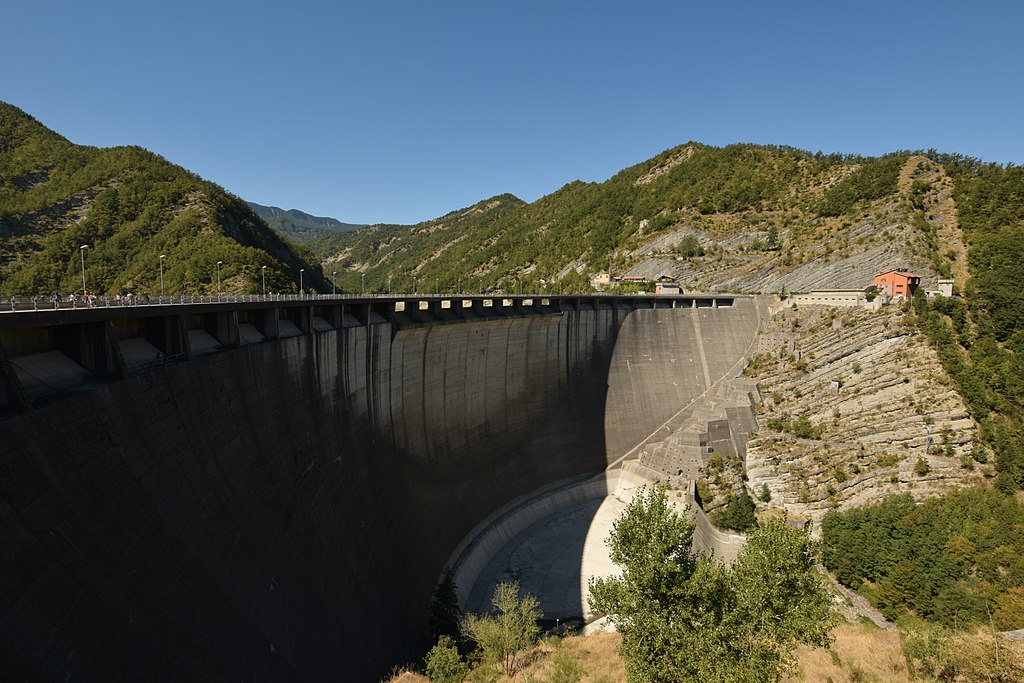
The use of realistic models for projecting the deterioration of infrastructure reduces risks, increases safety, and avoids costly corrective maintenance, thanks to photogrammetry with RPAs (remotely piloted aircraft).
The new technologies are proving an economical source of precise 3D data for the modeling and preventive maintenance of the Ridracoli Dam of Romagna Acque, Società delle Fonti, which applies aerial surveying to readily access hard-to-reach areas.
Monitoring of infrastructure and risk assessment
The Italian water utility Romagna Acque needed a rapid, economical, and precise alternative to the earth topographic surveying that it used to monitor the state of its infrastructure. The Ridracoli Dam across the Bidente river in the Foreste Casentinesi National Park provided a test bench for an innovative method of aerial surveying by means of radio-controlled drones equipped with cameras.
Italdron, a local company specialized in the aerial acquisition of data and images, part of the project team, conducted test surveys on the dam and buildings and used Bentley ContextCapture software for realistic modeling to convert thousands of images into a precise 3D model of the dam.
Using the images, ContextCapture automatically created a faithful, realistic model of the Ridracoli dam: the precision of the 3D model used for the preventive maintenance of this water supply dam was confirmed with maximum deviations of 2 centimeters by a study conducted by the University of Perugia. Properly calibrated, the model will enable Romagna Acque to project and forestall the deterioration of this strategic infrastructure.
The limitations of traditional surveying
Completed by Romagna Acque in 1982, the Ridracoli dam provides drinking water to 48 towns and cities in Emilia-Romagna. This double-curvature arch-gravity dam, 103.5 m tall and 432 m wide, holds 33 million cubic meters of water to feed the Romagna Aqueduct.
To maintain this enormous structure, the utility combines inspections with periodic topographic surveys. These surveys collect data for modeling the static and dynamic behavior of the dam to project potential deterioration and plan preventive maintenance. The model also enables the utility to predict and prepare for the impact of seismic events, temperature changes, and other environmental conditions.
Use of the traditional surveying method LiDAR (Light Imaging, Detection and Ranging) provided topographers with access to hard-to-reach areas of the dam, but this technique was often slow, costly, and difficult to use. Romagna Acque needed a more efficient method for collecting precise data on the dam, auxiliary buildings, and abutments.
Aerial photography was a promising alternative to land laser surveying, but its accuracy and precision had not yet been tested under those conditions.
We therefore proceeded to verify the precision of photogrammetry assisted by RPAs, thanks to collaboration with the University of Perugia, and to construct a realistic, functional model of the dam.
Unprecedented accessibility
The team for the aerial acquisition of data and images planned to conduct the aerial surveying in a single day, to minimize the effects of atmospheric variations on data collection. The upstream activity called for positioning 175 geolocalized targets around the dam and surrounding area to delimit the overflight area.
To obtain base data, the project team performed a topographic survey of the dam and auxiliary structures by total station, GPS station, and land laser scanning. For aerial surveying, we used RPAs vehicles in 19 overflights, each of 15 minutes, to acquire 4,600 images. The RPAs reached areas previously inaccessible, such as the portion downstream from the dam arch.
During post-processing, we used ContextCapture software from Bentley Systems to reconstruct the geometry of the structure based on thousands of images. The image processing technique aligned the 2D photographs within a 3D space to create a realistic 3D model of the dam and auxiliary buildings. The Bentley realistic modeling software generated dense clouds of 3D points and mesh models, and these results were verified for density, by points, lines, and surfaces, using traditional topography as a reference.
A comparison between the aerial topographic survey and those of land surveying clearly indicated that the use of RPAs was as precise as the LiDAR surveys, with deviations of between 2 cm and less than 1 cm.
The field testing demonstrated that aerial photogrammetry, processed with the Bentley ContextCapture software, could generate the highly detailed realistic 3D models Romagna Acque needed for its preventive maintenance program.
Validation of the results by comparison with known design geometry demonstrated that the technique offers a precise, realistic representation of the correct state of the dam. The realistic model was supplemented by existing data from design documentation of the owner and regional technical diagrams. The digitization of archives dating from 1974 offered a complete base for comparing past and present data. The integrated cloud of points provided the basis for a solid model with structural and mechanical properties.
After calibration with the appropriate properties of the materials and the static and dynamic loads, the model has become a valuable tool for a realistic projection of the dam's structural conditions over time.